Reach out to us
For booking, sales inquiries or travel insurance call us on
Call Us:
+254 769 677 263
Subscribe for updates & promotions
Get the latest insights and inspiration from us.

Suguta Valley, aka Suguta Mud Flats, is just one badass place!
It is also the most surreally beautiful place in Kenya!
A place so remote that the only people who have visited or seen it, have done so by air, or are very wealthy white folks who can spend pocket change like KES 1M for a 2-hour helicopter flight to see it. Or are engineers or officers who work for the government.
Or are locals. Yes, there are Kenyans living there. These are the toughest people in Kenya!
Due to Suguta Valley’s inaccessibility and harsh climate, with high temperatures, only the most determined tourists visit the place and get rewarded with an experience that’s equalled only by very few other places in the world.
But can anyone really appreciate how remote, and how beautiful Suguta Valley is, by air? You cannot.
That’s why the Mara Nomads have come up with this exciting, once-in -a-lifetime trip to visit this legendary place.
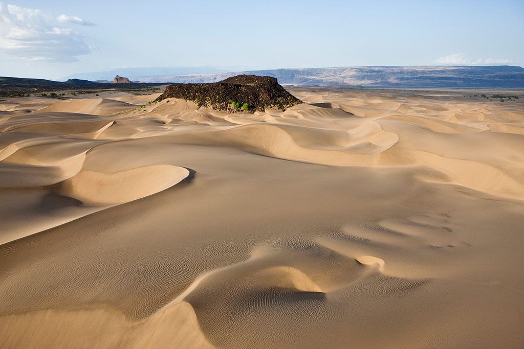
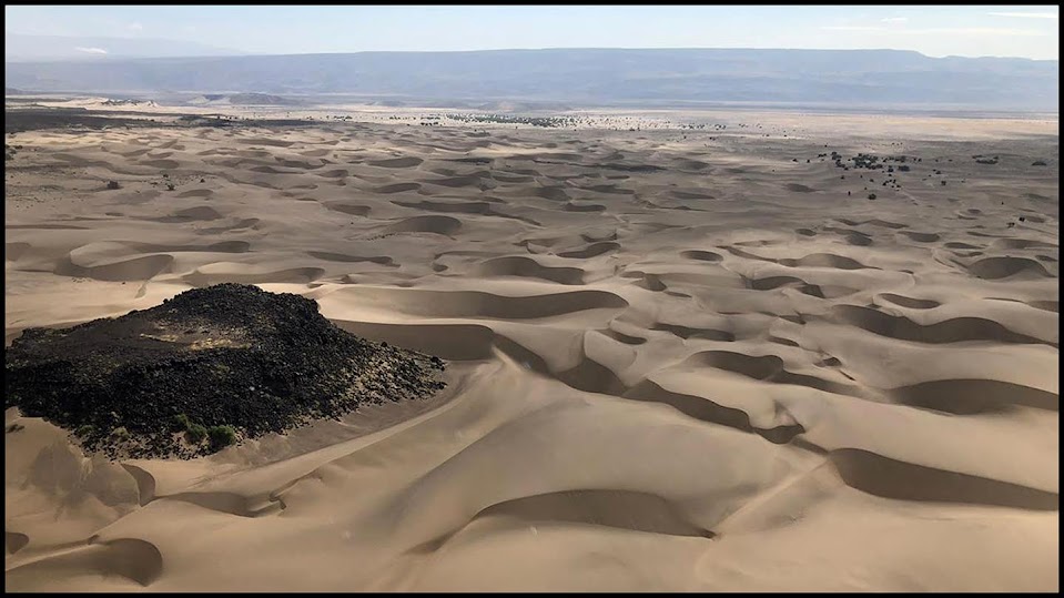
For many, North Horr is the only place with sand dunes. Correction, 1 sand dune. But what they do not know is that Suguta Valley is the true home of desert sand dunes. Golden in colour, fine sand that stretches for kilometers. Not just one dune but sand dunes upon sand dunes.
Getting there is not a walk in the park! The road, the terrain, the climate, will make it a taxing trip. This is one trip that only 4x4s will do.
Suguta Valley is a semi-desert part of the Great Rift Valley in Kenya, directly south of Lake Turkana. It is one of the driest places in Kenya, and claimed to be one of the driest places near Earth's Equator.
Lake Logipi which lies on the northern side of Suguta Valley, seasonally fills a small part of the northern end of the valley. So, we can say that Suguta Valley and Lake Logipi are proximate to each other
Suguta Valley has a relatively flat floor about 300 metres above sea level. It is bordered by land to the east and west rising to 1,000 metres and dotted with volcanic cinder cones. The Barrier Volcano separates it from Lake Turkana.
Mount Nyiro, the holy mountain of the Samburu, rises to the east of the Suguta valley. Namarunu Volcano, another ancient volcano, extends into Suguta Valley from the western side.
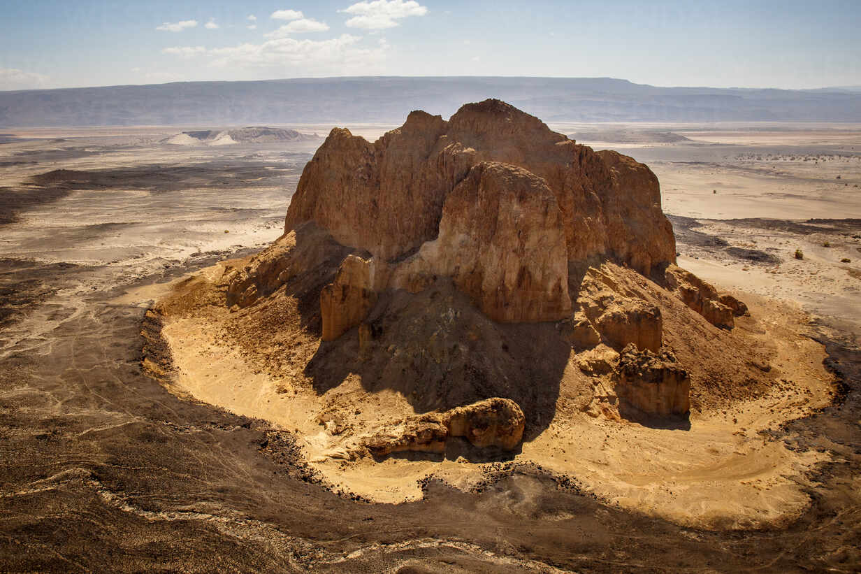
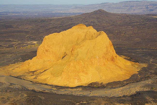
At the centre of Suguta Valley lies the conspicuous Aruba Rock surround by rows and rows of golden sand dunes. You crest a rise and Suguta Valley appears before you, looking resplendent like the mythical Eldorado, the City of Gold, spread out below and in front of you and Aruba Rock at the middle.
Aruba Rock is a black volcanic cone, not to be confused with the well known Cathedral Rock which is another cone that sits in the middle of the nearby Lake Logipi. From Suguta Valley sand dunes, you will glimpse the shimmer of Lake Logipi. The area around Suguta Valley is very colourful, with beautiful dry grass yellows, volcanic grays, rusts and blacks, and also far more green than you would expected but only of you went there during or after the rain season.
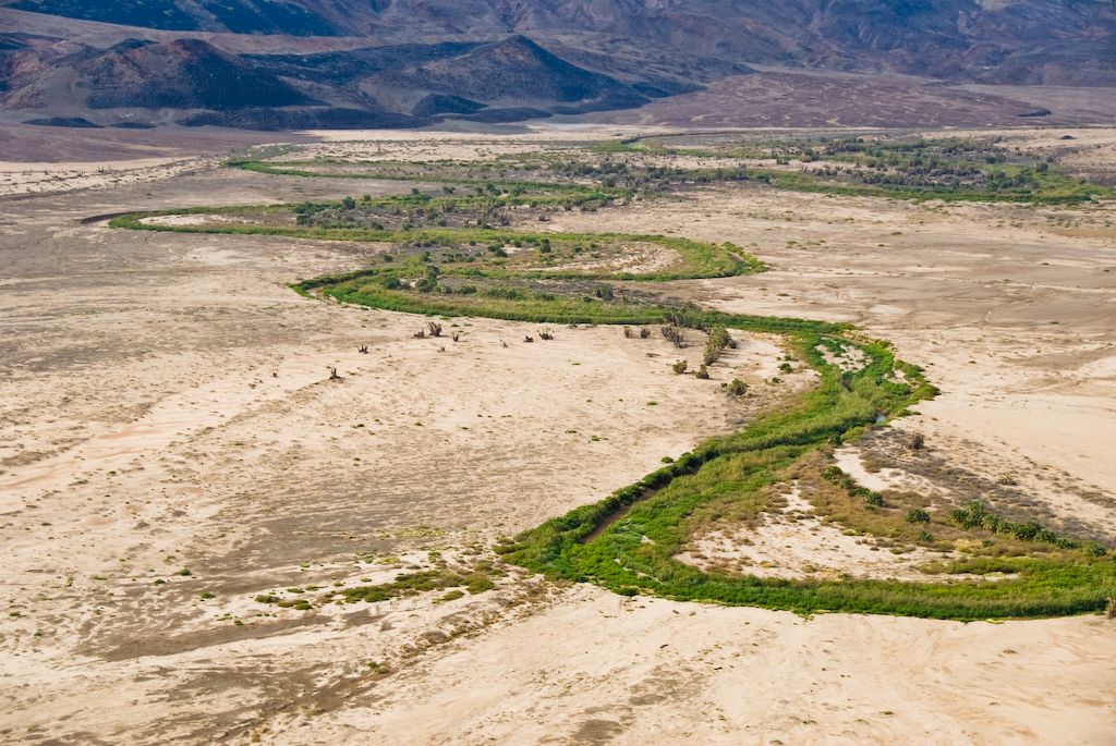
Depending on the season you will go there, you might encounter Suguta River with brown waters twisting its way down the centre of it all, flanked by daum palms on both sides going to Lake Logipi to empty its load.
Suguta Valley like Udûn (the Valley of Mordor in the Lord of Rings triology) is hemmed on all sides by mountains.
If Kenya was Middle Earth, Suguta Valley will be Mordor, Sauron’s abode, an impregnable fortress that hides secrets, that’s inaccessible to all but the most capable.
A place where Sauron’s Orc armies would be forging weapons and waiting for their master’s order to begin the battle of Middle Earth and establish Sauron’s dominion over the entire Middle.
On this trip, you will be Frodo Baggins and Samwise Gamgee who are traveling towards the Valley of Mordor (Suguta Valley) on an epic adventure but this time you will be passing through the Black Gate, the main entrance to the Valley and not through the inaccessible mountains surrounding it.
The Suguta Valley lies along the axis of the Gregory Rift, (a lesser-known branch of Rift Valley), which has been faulting for a long time along a belt 35 kilometres wide.
What we know as Suguta Valley was once a big lake, called Lake Suguta that filled the valley, at times overflowing into Lake Turkana. The lake’s water level rose and fell several times in the last 18,000 years due to changes of rainfall. The about 8,000 years ago, the lake’s water level fell by 250 metres and eventually dried out completely leaving behind a remnant, that is, Lake Logipi.
The massive ancient Lake Suguta, which once filled today’s dry valley, reached its maximum height of 570 meters about 13,000 years. This is when the entire area of Lake Turkana and Northern Kenya was much wetter and greener than today.
The area around Suguta Valley is still changing with tectonic plates moving away from each other. Its said that some day in the future, that entire area will split into two, forming a new continent from Afar in Ethiopia down to Mozambique. The same tectonic activity in the region has deformed the shorelines of the ancient lake.
Suguta River, a seasonal stream that flows northwards towards Lake Logipi, passes through Suguta Valley, just next to the sand dunes, helping drain the Valley. During rainy season, Suguta River, forms the temporary Lake Alablad, a playa lake (a shallow muddy lake that dries very quickly) that combines with Lake Logipi at the northern end of the valley.
Suguta River originates in a stream of near-boiling water that emerges from the side of Mount Silali, an extinct volcano not far from Suguta Valley. Some geologists speculate that the Kapedo Hot Springs, which drops through a set of waterfalls to the Suguta river, is the outlet from Lake Baringo 60km to the south.
At one-point Suguta River passes between two volcanoes and is fed from both sides by hot springs. The banks of the Suguta River are lined with hardy Doum palms, called Marara by locals. The river and its tributaries are home to a cichlid, the Suguta tilapia (Oreochromis niloticus sugutae). Although the river dries up after the rainy season, the fish survive in pools. The river is also home to numerous crocodiles. Large flocks of flamingos inhabit the edge of the river.
In the dry season, saline hot springs inside Lake Logipi help maintain water levels in Lake Logipi, which is about 3 metres to 5 metres at its greatest depth, about 6 kilometres wide and 3 kilometres wide.
Lake Logipi’s saline waters provide food for cyano-bacteria and other plankton, which in turn are food for flamingoes that throng the lake in hundreds of thousands every year, creating a most surreal beautiful view.
